Frazzini | Emiliano Frazzini | Lucrezia Carlini | Benilda Frazzini | DiVecchia | Site Home |
Dawson,
NM |
Ely,
NV |
Odgen,
UT |
Raton,
NM |
Aurora, MN |
San Pietro Avellana |
The center of this line ran along the Sangro River near SPA. The destruction of the town, along with many others around it including Castel di Sangro, was to deny shelter and cover to the Allies who were expected to go around the more heavily defended western section of the Gustav Line. The Allies, though, went headlong against the Gustav Line and the Battle at Monte Cassino ensued. (Note : during this campaign, there was battle named "The Battle of San Pietro Infine" or "The Battle of San Pietro". This battle had nothing to do with San Pietro Avellana.)The Winter Line was a series of German military fortifications in Italy, constructed during World War II by Organisation Todt. It ran across Italy from just north of where the Garigliano River flows into the Tyrrhenian Sea in the west, through the Apennine Mountains to the mouth of the Sangro River on the Adriatic Sea in the east. The centre of the line, where it crossed the main route north (Highway 6), was based on the mountain Monte Cassino and the old abbey that sat atop it. The line was fortified with gun pits, concrete bunkers, turreted machine-gun emplacements, barbed-wire and minefields. It was the strongest of the German defensive lines south of Rome. The western part of the line, centred around Monte Cassino, was called the Gustav Line, and was protected by the Bernhardt Line a few miles to the south.
Following the Allied invasion of Italy in September 1943, the Italian government had surrendered, but the German Army continued to fight. The Allied armies succeeded in conquering the southern part of Italy, and the Germans retreated to a prepared defensive position called the Winter Line. About 15 German divisions were employed in the defence.
The Allies' immediate objective was the liberation of Rome. The most obvious approach to Rome was the Liri Valley (just north of Monte Cassino), and the Winter Line would prevent the Allies advancing to there.
The German forces were commanded by Field Marshal Albert Kesselring. The defence of the line itself was commanded by General Heinrich von Vietinghoff of the 10th Armee.
The Winter Line proved a major obstacle to the Allies at the end of 1943, halting the Fifth Army's advance on the western side of Italy. Although the Gustav Line was penetrated on the Eighth Army's Adriatic front, and Ortona captured, blizzards, drifting snow and zero visibility at the end of December caused the advance to grind to a halt.
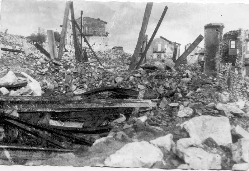
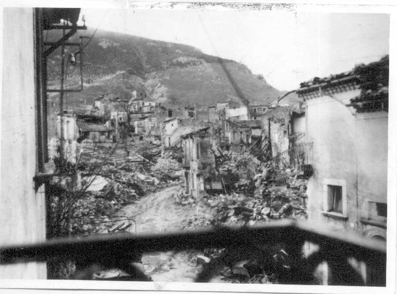
Here is a view of San Pietro taken from the mountain across the valley. You can see the dust from a series of explosions. Might have been taken from near the Chapel of Saint Amico. |
A family in probably the rubble of their home. |
Here is the church surrounded by rubble. The church was one of the few if not the only building not destroyed. |
The church is in the center background. |
22 Nov 1943 - Reno Evening Gazette |
23 Nov 1943 - Times Record (Troy, NY) |
1943 Dec 6 - Chicago Tribune - notice the reference to aerial photographs taken of SPA. For the full article, click here. |
From:
Mark DiVecchio <markdsilogic.com> To: evidenceincamerakeele.ac.uk Subject: Aerial Photos Taken in Italy during WWII Date: Sat, 28 Oct 2006 13:57:31 -0700 Dear Sirs, I need your advice on how to proceed in locating several aerial photographs taken on the Italian Peninsula in 1943. My mother's hometown is San Pietro Avellana. That town is near Castel di Sangro and was located along what was known as the Winter Line (the west end of which was the Gustav Line and the site of Monte Cassino). As the Allies were moving north approaching the line, the German army was busy flattening towns along the line to deny the Allies cover. One of those towns was San Pietro Avellana. On my web site, I have several photos taken of the town after its destruction. I just found a newspaper article from the Chicago Tribune dated 6 Dec 1943. I've attached a copy. This article refered to aerial photographs shown to the press: "Aerial photographs of the village of San Pietro Avellana on the upper reaches of the Sangro river were shown correspondents today demonstrating how the Germans are destroying every village in the path of the allied troops. The photographs showed the village as normal on Oct. 14 and another picture a month later showed only empty shells where the village used to be. This town had a population of about 2,000." The town was eventually liberated, without resistance, by the 10th Belgian Commandos attached to the British 8th Army. The 8th Army was responsible for this sector of combat so I am hoping that the photos can be found in your archives. Locating these photos would be a milestone for the people of San Pietro Avellana who are trying to rebuild their town even today. Sincerely, Mark DiVecchio markd@silogic.com |
Date:
Sat, 28 Oct 2006 21:57:33 +0100 From: evidenceincamera <evidenceincameralib.keele.ac.uk> Subject: Re: Aerial Photos Taken in Italy during WWII To: Mark DiVecchio <markdsilogic.com> Re: Aerial Photos Taken in Italy during WWII Thank you for contacting The Aerial Reconnaissance Archives (TARA). SUMMER 2006 CLOSURE: TARA will be now be closed until Tuesday 29 August. We apologise for any inconvenience this may cause. The future of TARA is the subject of ongoing discussions between Keele University and The National Archives. As a consequence of this, and the continuing high level of demand for our services, there will be some delay in our responding to your enquiry. In early September we shall be launching an online research service to better manage customer enquiries. |
Our cousin,
Guiliano Colajanni, was able to find these two photos. From The
Illustrated London News 25 Dec 1943
'An Aerial View of San Pietro, A Peaceful Mountain Village: The Germans on Retreating Deliberately Destroyed Every Habitation' 'Another View of San Pietro - Not a Single Allied Bomb Was Dropped Here' The ILN Picture Library web site. An Illustrated London News fan site.Look at the current aerial photos of SPA at Google Earth. I asked Giuliano where he found these photos and he replied: Caro cousin
You won't believe, the photos was in the SPA's Museum. In a file there was a newspaper page with on facing and opposite many photos of war along Sangro River. I asked to Mariateresa Di Lorenzo, director, to copy the page. I made a plastic big copy, stupend!! A big CIAO |
email : markd@silogic.com
DiVecchio HOME
Frazzini HOME
Site HOME
Join our San Pietro Avellana email mailing list here :
https://groups.google.com/d/forum/sanpietroavellana
If you can help with the expenses to develop this web site: